
 1
1 
 7
7 
Circuit Bomal-sur-Ourthe (Durbuy) - The Saint Rahy walk
Bomal
On foot || Middle || 4:00 ||
 9.86 km


 2
2 


Walking trail Hotton -17- Walk along the stones
Hotton
On foot || Middle || 1:50 ||
7.01 km


Beauraing 2
Beauraing
On foot || Middle || 4:00 || Trail || Middle || 2:00 ||
15.0 km
 croix jaune 2


Belvaux - Les Bouvreuils - The rapids of the Lesse
Rochefort
On foot || Middle || 2:00 ||
5.63 km


Les Rouges-Gorges
Belvaux
On foot || Middle || 3:45 || People with limited mobility || Pushchair ||
10.0 km


UNESCO Global Geopark Famenne-Ardenne : Geotrail of Durbuy


"The Durbuy meander cutoff ":
Durbuy owes its existence to its remarkable geological setting. The town first came into existence as a military stronghold, located on a tight loop of the River Ourthe, encircling a limestone outcrop. This strategic position combined two advantages: the outcrop provided a solid vantage point on which to build the fortress, and the meander offered a natural defence against attackers. A thousand years on, it is by no means easy to imagine how the landscape would have looked at the time of this human conquest. In addition to all the building that has taken place in the intervening centuries, the course of the River Ourthe itself has also shifted. This suggested trail gives you some idea of what that initial landscape would have looked like, including an unobstructed view of the Ourthe, the line of its long-vanished branch, and a chance to observe both the large and the small Durbuy anticline. The nameof Durbuy is thought to derive from the Celtic duro-bodion, “ the dwelling place near the fortress”. As an added bonus, the trail also takes you through the old town with its well-preserved ancient houses and cobbled streets.
IGN MAP

AERIAL PHOTOS / IGN


SLOPE MAP (IGN PLAN)


MAP 1950 / IGN

MAP OF THE GENERAL STAFF (1820-1866)


OPEN STREET MAP


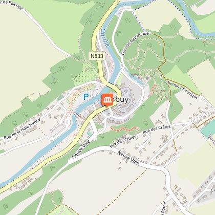
Starting point
6940 Durbuy
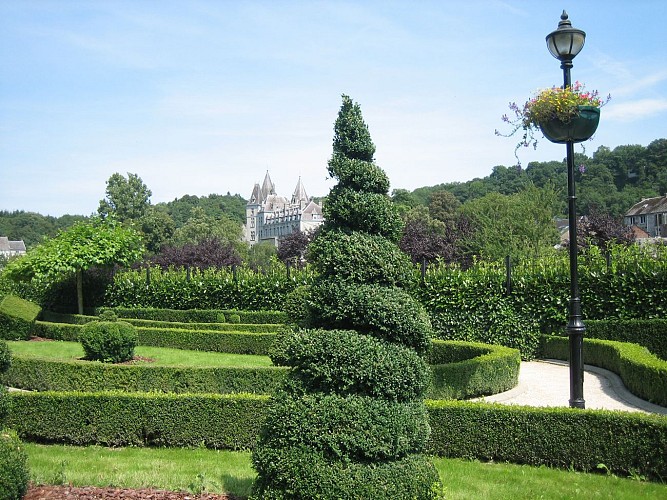
Topiary Park
You are now walking alongside one of Durbuy’s most famous attractions. The Parc des Topiaires, on the banks of the Ourthe, is home to over 250 different topiary figures shaped out of boxwood. Don’t be surprised if you come across a mermaid, an elephant, a crocodile or even our old friend from Brussels, “Manneken-Pis”. The practice of clipping bushes and shrubs to form shapes dates back to Roman times, more specifically to the time of Pliny the Younger (62-113 AD). He used the term topiarusto refer to his gardeners, brought from Egypt or Syria as slaves It was they who introduced the art of topiary, the trimming and clipping of bushes, shrubs and trees into the shapes of wild animals or mythical figures. The plant most commonly used for this purpose tends to be box, Buxus sempervirens, but other suitable candidates include yew, laurel, spindle tree, holly and cypress. The art of topiary died out with the fall of the Roman Empire, and was not revived until the Renaissance. Some of the plants in this park are over 120 years old, tributes to the perseverance and patience of their artist-gardeners in creating these slowly-maturing works of art. For some of them, it has taken almost 20 years of painstaking shaping and clipping.
Le parc des Topiaires
Rue Haie Himbe 1 6940 B-Durbuy
tel. : +32(0)86/219.075
Courriel : topiaires@durbuy.be
Web : www.topiaires.durbuy.be
Open from 2 January to 31 October
(10am to 6pm);November (10am to
5pm);December (weekends and school
holidays, 10am to 4 pm)
€4.50 per person (free for children under
6, €1 each for children under 12).
After admiring the amazing topiary on display, be sure to pause and take in the view from one of the finest terraces in Durbuy !
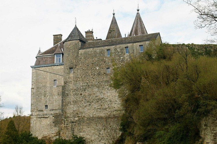
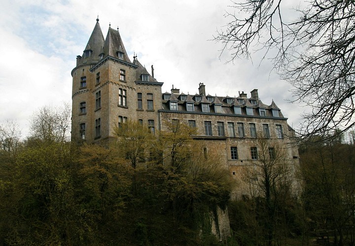
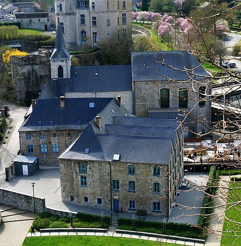
The Castle of Durbuy
The town of Durbuy grew up on an island encircled by a meander cutoff of the River Ourthe, a position of great strategic importance. The site relied for its defence on the river surrounding the fortified enclosure, and on the castle, built on a rocky spur. It was not until the 18th century that the meander was drained and filled in, leaving the dry bed of the former course where you now stand. Facing you stands the Chateau.
The town of Durbuy, first mentioned in written records in 1078, owes its existence to the castle. This landmark has had a chequered history, falling prey over the course of time to fire, dilapidation and destruction, alternating with periods of reconstruction. In its earliest form, the fortress was built primarily for military purposes, consisting of a platform on which stood a number of buildings and towers making up the fortifications. Accommodation was restricted to the bare minimum. From the 15th century onwards, the castle was to offer more comfortable quarters as rooms were added on the town side of the keep. The castle survived a number of wars before finally being razed by French troops in the 17th century. In 1731, the Duc d’Ursel, lord of Durbuy from 1726, embarked on its reconstruction. What he built, however, was not a fortress but a château, a courtly residence on the banks of the Ourthe. The chateau underwent further radical changes around 1880- 1882, giving it the neo-Gothic style it retains to this day. As the riverbank reveals, the base of the chateau rests on the limestone rock itself, providing solid foundations for the chateau. Between the chateau and the cutoff stands an impressive folded rock formation:the small anticline (geological details below). This anticline, along with outcrops along the course of the Ourthe, reveals the existence of a rock several metres in height on which the chateau is built, makingit a natural vantage point over the surrounding terrain.
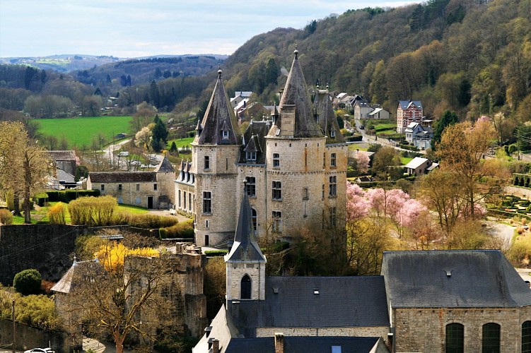
Durbuy Old Town
It was in 1078 that Durbuy was first mentioned in a written record, under the name of Dolbui castello. In the 12th-13th centuries, we find written references to the city of Durboiensis, translated as “Fortress of the Boïens”. As we have seen, the town originally came into existence to serve a military purpose. That military strength enabled Durbuy to extend its protection to neighbouring villages and thus become a prosperous social and economic centre. As a major iron-founding centre in the 16th century, Durbuy and its 20 furnaces provided the Liège region with half of all its iron needs between 1530 and 1570. Durbuy was to decline in the 17th century, however, due to misfortunes and wars. Religious communities moved into the town to bring succour to the population, and their splendid convent buildings remain to this day.Economic renaissance was not to come until the late 19th century, however, with the rise of tourism. Durbuy is fortunate in possessing so many beautiful buildings, including its magnificent chateau rising above the town on its rocky peak. Its picturesque narrow lanes tempt the visitor to wander at will and explore the many and varied small shops and businesses to be found, including a wide choice of restaurants offering gourmet dining, local cuisine or a typical brasserie experience.
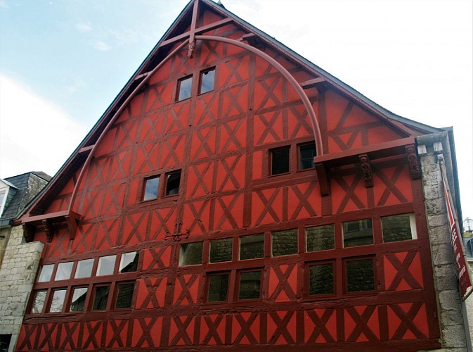
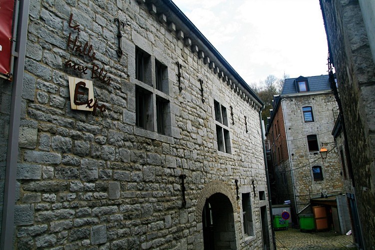
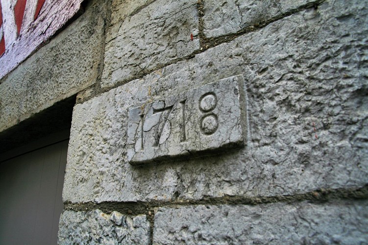
The Halle aux Blés
Let us linger for a moment outside one of the town’s iconic buildings, the Halle aux Blés or corn exchange, also known as the Spanish House. The earliest references to a building on this spot date from 1380, but the building we see today, with its extremely rare half-timbering, dates from the 16th century (around 1530- 1540) and bears witness to the economic importance of Durbuy at the time, whose lands covered what are now several different communes. Its designation as the Halle aux Blés is somewhat misleading, and dates from the 19th century. The building in fact served a number of different purposes, housing both a covered market and the magistracy (the administrative and judicial centre for the county). The town declined in importance in the 17th century, as a result of the Thirty Years War and the disappearance of the iron-founding industry. The building fell into disrepair and the rear half, which had housed the covered market, had to be demolished in 1639. In the 18th century, it underwent further transformations but retained its role as the town hall until the end of the century. The building is now listed as an outstanding example of Wallonian heritage (as of 23/11/1976) and is home to the Durbuy Museum of Modern and Contemporary Art.
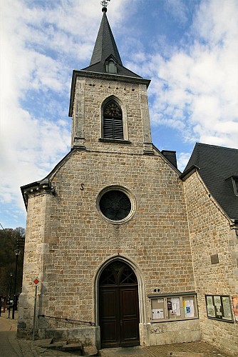
St. Nicolas Church
This was originally known as the Récollets church. It was founded in 1632 by the Récollets religious order of mendicants and preachers, and consecrated in 1642. The front part of the present church corresponds to the earliest building. The church was restored and considerably extended in the 18th century. The Dukes of Ursel, who financed the work, had their coat of arms mounted in the vaulting of the choir, bearing the date of completion of the work in 1774. After the Revolution, the church was granted to the municipality, which undertook its restoration, and became a parish church by the name of Saint Nicolas. It features some superb 16th century baptismal fonts. Adjoining the church once stood the Récollets convent, construction of which began in 1629. The site today consists of the former presbytery, buildings now used as apartments and shops, and a public garden. Opposite the church is the current entrance to the chateau (which used to be opposite the Halle aux Blés).
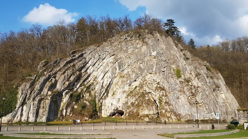
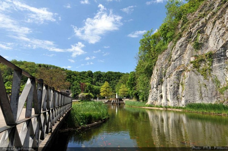
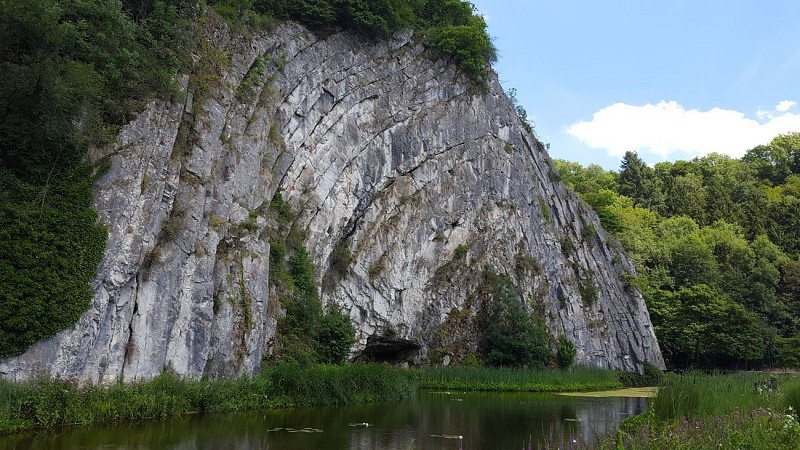
Durbuy Anticline
You are now standing in front of the Durbuy Anticline, otherwise known as the Rocher de la Falize (Al Rotche al Falèye), also otherwise known as the Omalius Anticline in honour of the famous Belgian geologist Jean-Baptiste-Juliend’Omalius d’Halloy(1783-1875). It was he, one of the pioneers of geology in Belgium and Northern France who, in 1807, first described the rock in a scientific journal. The anticline is a geological phenomenon, unique by virtue of its situation, its size and its ease of observation. So, now for a brief geology lesson. The Omalius Rock is what is known as an anticlinein geological terms. An anticline is an A-shaped fold in a rock layer. Its inverse, a V-shaped fold, is known as a syncline. It is made up of well-stratified Frasnian limestones. Going back in time to the Frasnian stage, between 385 and 375 million years ago, the Geopark lay beneath the southern tropic in a warm ocean. The ocean bed was made up of alternating deposits of carbonated mud and layers of reef-building organisms (corals, sponges, etc.), forming horizontal banks. In order to take on the folded appearance we see today, these banks had to be forced out of shape. This forcing occurred when the earth’s crust was compressed. In Belgium, this happened when a mountain chain was formed some 320 million years ago (the Variscan orogeny). When the force of the pressure became too great, the banks snapped. The resulting mountain chain was subsequently eroded away to a flat, featureless surface known as a peneplain. Rivers then incised their way into this rocky base to form the landscapes we see today.

5580 Rochefort


