
 7
7 
 1
1 
Circuit Bomal-sur-Ourthe (Durbuy) - The Saint Rahy walk
Bomal
On foot || Middle || 4:00 ||
 9.86 km


 2
2 


Beauraing 2
Beauraing
On foot || Middle || 4:00 || Trail || Middle || 2:00 ||
15.0 km
 croix jaune 2

Walking trail Hotton -17- Walk along the stones
Hotton
On foot || Middle || 1:50 ||
7.01 km


Belvaux - Les Bouvreuils - The rapids of the Lesse
Rochefort
On foot || Middle || 2:00 ||
5.63 km


Les Rouges-Gorges
Belvaux
On foot || Middle || 3:45 || People with limited mobility || Pushchair ||
10.0 km


UNESCO Global Geopark Famenne-Ardenne: Geotrail of Hotton


Hotton lies within the Famenne in the Ourthe valley, just downstream of where the river runs through the limestone layers of the Calestienne. This trail will take you from one side of the Calestienne to the other, on both sides of the Ourthe valley. In the river valleys (Ourthe and Agauche), erosion has revealed the limestone rock in spectacular fashion, perfectly illustrating the almost vertical inclination of the strata. Elsewhere, it is mainly disused quarries that provide a better understanding of the region’s geology and the role it has played in shaping the landscapes and the development of local socio-economic activity: ancient buildings, mineral resources, agricultural methods. Capping it all, the Caves of Hotton offer visitors a chance to see for themselves what lies underground. The shorter option for this trail covers 7.3km, increasing to 8.9km if you take the routes via the Agauche stream, the Calestienne Garden and the Isbelle resurgence.
IGN MAP

AERIAL PHOTOS / IGN


SLOPE MAP (IGN PLAN)


MAP 1950 / IGN

MAP OF THE GENERAL STAFF (1820-1866)


OPEN STREET MAP


Starting point
6990 Hotton
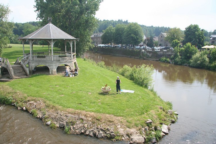
The island of l'Oneux
Bordered by the Ourthe on one side and the Bief du Moulin (a backwater of the Ourthe), the island of l’Oneux consists of 6 hectares ringed by tall poplars, in the very centre of Hotton. The soil of the perfectly flat island is made up of sediments carried along by the river and then deposited, known to geologists as alluvium. The island provides a setting for much of the village’s recreational and cultural activities. Walk across the island in a south-easterly direction to the second footbridge, which crosses the Ourthe. After the footbridge, cross the road and carry straight on along a narrow path that leads to the municipal park. Take the path that leads up to the top of the park (elevation gain 30 metres).
The Hotton Arboretum
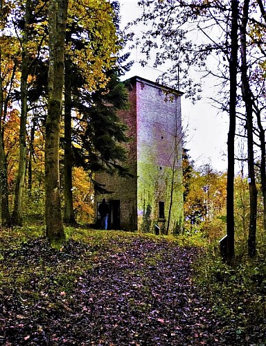
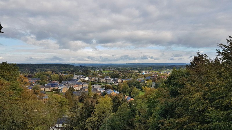
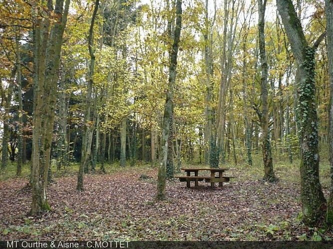
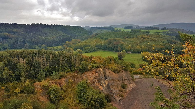
For the first geosite on your route, head for the arboretum in Hotton’s municipal park, and its observation tower. The park lies on the left bank of the Ourthe, on the outskirts of the village of Hotton. This wooded area is home to a variety of different tree species, plus a picnic area. Unless you suffer from vertigo, climbing the 7 metre spiral staircase in the middle of the park tower is an experience not to be missed. Ideally positioned on the last remaining limestone beds of the Calestienne, the tower looks down over the Ourthe Valley and the Famenne. The vantage point from the top of the tower is one of the highest to be found in the Calestienne and offers wonderful views, not only of the villages of Hotton and Melreux but also of the Famenne depression and the Condroz (in the distance).
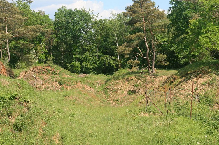
Alouette Quarry
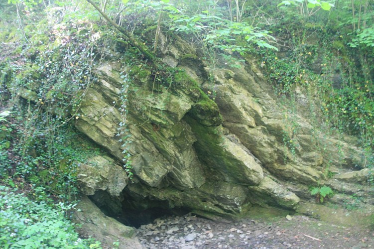
L’Alouette is a quarry, now abandoned, on land that forms part of the village of Menil-Favay, and was first worked in 1899. Unlike the region’s other quarries, which extract limestone, L’Alouette quarried a layer of often extremely hard Eifelian sandstone (quartzite) some twenty metres thick. The quarry no doubt started out producing the fieldstone, rough or dressed, used in the construction of buildings in the village of Ménil-Favay. The quarry also produced aggregates for road-building, as witnessed by the remains of the crushing units still partially visible on the site. After quarrying was abandoned, the quarry was purchased by the municipality of Hotton (1983) and was used for some time as a tip (1985). In 2012, the site was officially declared a stateowned nature reserve (RND). Local wildlife is protected, and visitors are asked not to pick flowers or disturb the peace and quiet of the site. Sheep and goats are regularly pastured here as a natural means of keeping the grass under control and thereby preserving the site’s biodiversity. The quarry marks the point of contact with the limestone rocks already visible on the north face of the quarry. This point where sandstone, consisting for the most part of quartz, meets limestone, mostly consisting of calcite, is one of the factors explaining the outstanding flora to be found here, with a particular wealth of orchids. The site is also home to a number of reptiles and no fewer than 34 different species of diurnal butterflies. The quarry looks down over the Agauche valley, and some of the spoil from the old workings has diverted the course of the water, maskinga swallow-hole connected to the underground river that flows through the Caves of Hotton.
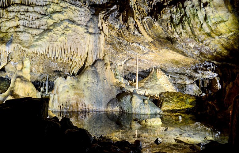
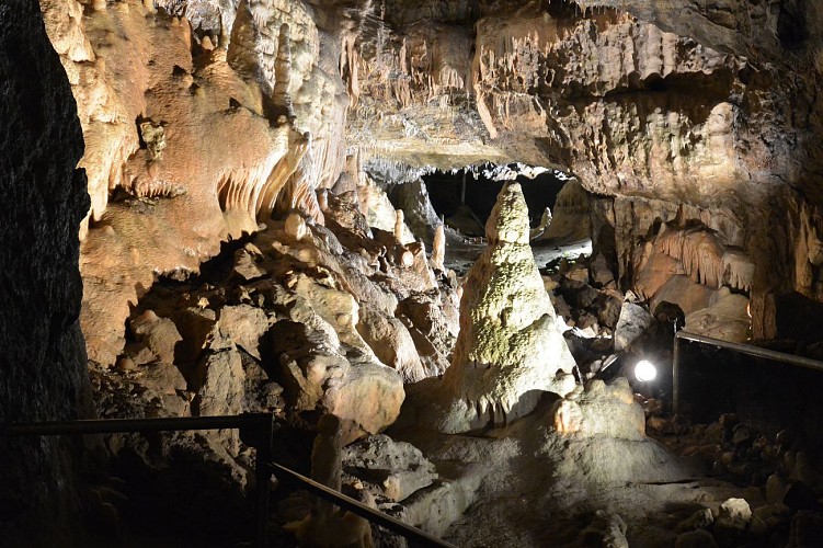
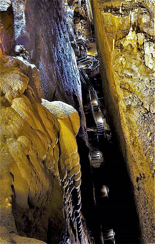
The Hotton Caves
The Caves of Hotton were discovered by chance in 1958 in the eastern working face of the Hampteau quarry when blasting uncovered a highly concretionary underground gallery. This gateway to a vast underground network of caves marked the beginning of a long history of speleological exploration and scientific study that culminated in the founding of a company to exploit the tourist potential of part of the network. This meant that a new entrance had to be created on the plateau, and the quarry had to be closed, since it was demolishing the finest chambers. The Caves of Hotton now consist of 5km of galleries, through which an underground river runs, and a drop of 70 metres. The river water comes from a number of swallow-holes aligned along the plateau near the hamlets of Verdenne, Marenne and Menil-Favay, and emerges at the Ourthe. This type of karst system involving several swallow-holes feeding an underground flow is known as a swallow-hole-resurgence system. Exploration of the caves is ongoing, but has currently come to a halt at yet another sump, or siphon, the eighth so far. The cave complex is made up of several superimposed layers, through the lowest of which flows the river. The higher levels feature a wealth of highly varied concretions.
The Calestienne Garden
A stone’s throw from the Caves, the Calestienne Garden (admission free) showcases the calcicolous (chalk-loving) plants characteristic of the Calestienne. This route will take you to the top of the Hampteau quarry where the Caves of Hotton adventure first began. From this vantage point, you will enjoy a remarkable view over the valley of the Ourthe as it carves its way right across the limestone band. Further afield, the view extends to embrace, from north to south, the Condroz, the Famenne depression, the village of Hotton, the Renissart Rocks, the valley of the Isbelle tributary, the village of Hampteau and the Ardennes.
Danger : no matter how tempting it may seem, we strongly discourage the more adventurous visitors from climbing over the fence in an attempt to get closer to the edge of the precipice. Not only is there the risk of a 30-metre fall, but the quarry walls are particularly unstable given the vertical inclination of the strata and the method of quarrying once used (blasting); rock falls are a common occurrence, which is why the quarry itself is also off limits to the public.
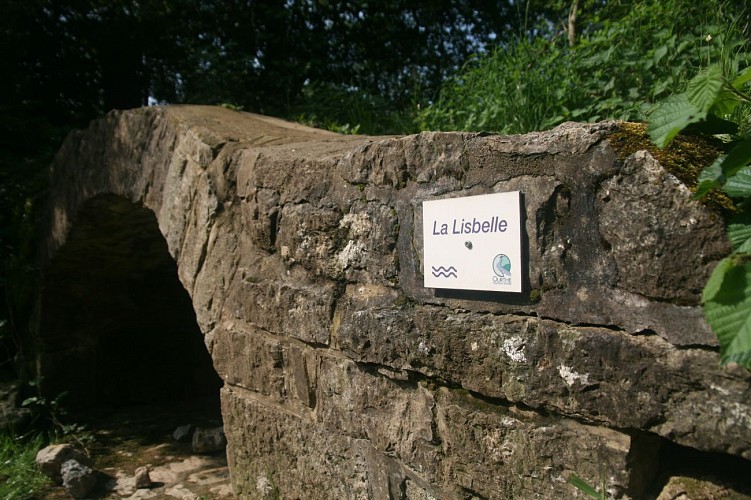
The Isbelle Resurgence
The Isbelle resurgence can only be accessed by divers. It is a visible sign of an underground river most
of which is still unknown to humankind. The spring is fed from swallow-holes higher up the valley. The spring ceases to flow in dry weather, but after heavy rainfall the Isbelle resumes its course above ground.
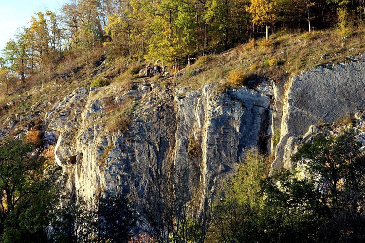
The Rocks of Renissart
On the heights of the Renissart Rocks once stood the Roman camp of Ti-Château, covering an area of 1.7 hectares. From this strategic vantage point, the garrison was well placed to keep a watch on the River Ourthe and stand guard over the farms clustered below. A number of coins and gold artefacts dating from the days of the Roman Empire have been discovered on the site. Close by is the Trou Fré Djame (Brother William’s hole), a feature standing 20 metres above the Ourthe and named after a monk said to have lived there as a hermit long ago. The feature consists of a corridor beneath a rock arcade that cuts right through the rock, providing protection for a 5-metre long rock platform. The smooth surface of the passage and its virtually circular cross-section indicate that it was formed by limestone dissolving (karstification) and represents the remains of a former karst system nowexposed by erosion. Traces of Neolithic remains have been found at the site. The Rochers de Renissart geosite consists of a limestone massif with karst cavities that rises above the Ourthe, facing south. The site is of great interest on many fronts, as part of the landscape, geologically, biologically, archaeologically and historically, not to mention the leisure opportunities it provides. Some sections of the rock are suitable for climbing, and very popular with climbers in the Geopark. A total of 102 climbing routes are available to members of Belgian climbing clubs. A climbing guidebook can be purchased from the tourist office (syndicat d’initiative)in Hotton. The beach at the foot of the rocks is ideal for spending a relaxing day by the waterside.
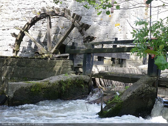
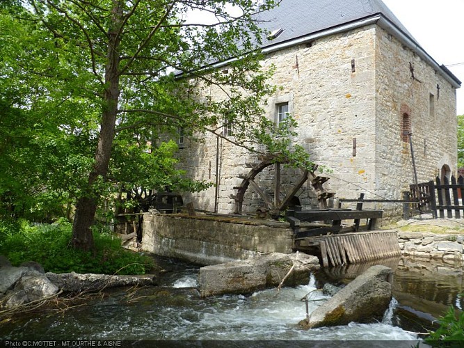
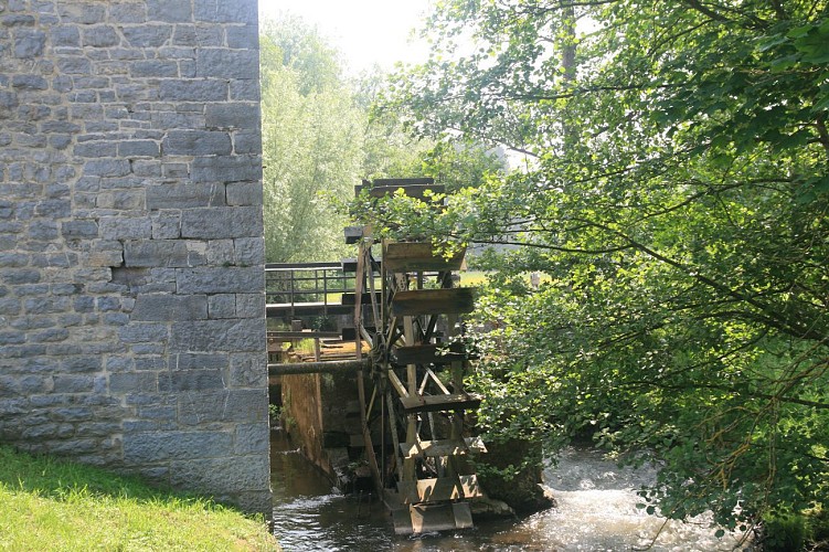
The Faber Mill
Built in 1729, the mill is still in working order, although it now operates purely for the benefit of admiring visitors, recreating the very essence of bygone days. It was built on the bank of a mill-pond, a branch of the
Ourthe that created an island (the Ile de l’Oneux). In those days, it was a communal milland residents were
supposed to have their grain milled at the seigneury mill, for which they would have to pay a milling tax according to the quantity of grain milled. The mill continued to operate until the early 1960s, and owes its name to its last owner, a Monsieur Fabre, who wanted the building to be opened to the public. Ownership passed to the municipality of Hotton in 1989. The interior bears witness to the ingenuity of the millers of yesteryear, and consists of four floors housing the machinery, the pairs of millstones, the sifter, the granary, etc. Outside the building, admire the two water-wheels, powered by the mill-race. The mill was listed by the Royal Commission for Monuments and Sites in 1948. Visits can be arranged on application to the tourist office.
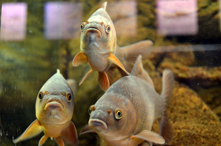
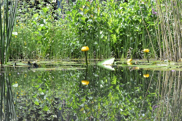
RIVEO
You have now reached the final geosite on your geotrail through Hotton. Riveo, the River Interpretation
Centre, stands ready to unveil the river’s secrets just for you. In the centre of Hotton, Riveo offers a variety of discovery areas, including a 12-metre long reconstruction of a branch of river, different aquariums, a pond (with underwater viewing gallery), and an entertaining themed exhibition. By appointment, Riveo will initiate you into the unsuspected treasures of the river world and all its biodiversity via a wide range of nature and fishing activities.

5580 Rochefort


