Geology & rocks

Signposted walk 1 (Fond des Vaulx)

Signposted walk 1 (Fond des Vaulx)

Marche-en-Famenne

On foot || Easy || 1:30 ||

6 km   1

Read more
8 LOD-A0-0030-2PMF 50.22951 5.34297
Felenne 7

Felenne 7

Felenne

On foot || Middle || Trail || Easy ||

10.0 km   7

Read more
8 ITB-01-000A4W 50.06775 4.84857
Circuit Bomal-sur-Ourthe (Durbuy) -  The Saint Rahy walk

Circuit Bomal-sur-Ourthe (Durbuy) - The Saint Rahy walk

Bomal

On foot || Middle || 4:00 ||

9.86 km  

Read more
8 LOD-A0-008D-86UA 50.37907 5.52197
Signposted walk  2 (Paquerette/Daisy)

Signposted walk 2 (Paquerette/Daisy)

Marche-en-Famenne

On foot || Easy ||

9.8 km   2

Read more
8 LOD-A0-0030-2Q6U 50.22951 5.34297
Felenne 3

Felenne 3

Felenne

On foot || Middle || 2:40 ||

10.0 km   3

Read more
8 ITB-01-000A4Y 50.06775 4.84857
Felenne 1

Felenne 1

Felenne

On foot || Middle || 2:45 ||

9.0 km  

Read more
8 ITB-01-000A4R 50.06775 4.84857
Promenade Hotton - 8- La Porte Aïve

Promenade Hotton - 8- La Porte Aïve

Hotton

On foot || Middle || 1:55 ||

7.15 km  

Read more
8 LOD-A0-008D-855J 50.2682 5.44797
Felenne 2

Felenne 2

Felenne

On foot || Middle || 3:15 ||

11 km   2

Read more
8 ITB-01-000A4S 50.06775 4.84857
Beauraing 1

Beauraing 1

Beauraing

On foot || Easy ||

7.5 km  

Read more
8 ITB-01-000A4H 50.10876 4.95972
Felenne 8

Felenne 8

Felenne

On foot || Middle || Trail || Easy ||

10.5 km   8

Read more
8 ITB-01-000A4U 50.06775 4.84857
Walking trail  Hotton -17- Walk along the stones

Walking trail Hotton -17- Walk along the stones

Hotton

On foot || Middle || 1:50 ||

7.01 km  

Read more
8 LOD-A0-008D-84N1 50.26833 5.44806
Beauraing 2

Beauraing 2

Beauraing

On foot || Middle || 4:00 || Trail || Middle || 2:00 ||

15.0 km   croix jaune 2

Read more
8 ITB-01-000A4I 50.10876 4.95972
Felenne 4

Felenne 4

Felenne

On foot || Middle || 1:15 ||

3.5 km   4

Read more
8 ITB-01-000A4V 50.06775 4.84857
Les pierres de légendes ( 1 ) (Commune DURBUY)

Les pierres de légendes ( 1 ) (Commune DURBUY)

Durbuy

On foot || Easy || 0:00 ||

6.36 km  

Read more
8 LOD-A0-008D-8J6A 50.32643 5.53234
Felenne 6

Felenne 6

Felenne

On foot || Easy || 1:45 ||

7.5 km   6

Read more
8 ITB-01-000A4X 50.06775 4.84857
Belvaux -  Les  Bouvreuils - The rapids of the Lesse

Belvaux - Les Bouvreuils - The rapids of the Lesse

Rochefort

On foot || Middle || 2:00 ||

5.63 km  

Read more
8 LOD-A0-008D-83PG 50.10607 5.19648
Les pierres de légendes ( 2 ) (Commune DURBUY)

Les pierres de légendes ( 2 ) (Commune DURBUY)

Durbuy

On foot || Easy || 1:15 ||

4.98 km  

Read more
8 LOD-A0-008D-8JMO 50.32641 5.53221
Les Rouges-Gorges

Les Rouges-Gorges

Belvaux

On foot || Middle || 3:45 || People with limited mobility || Pushchair ||

10.0 km  

Read more
8 ITB-01-000ATX 50.1658 5.18916
Les apéros feschautois

Les apéros feschautois

Feschaux

km  

Read more
9 EVT-A0-008J-1BKG 50.14726 4.9121

AND GEOTRAILS

Types of practices
Difficulty
Distance
Duration
Order
Reset filters

The Halle aux Blés

The Halle aux Blés
blur-effect
The Halle aux Blés
The Halle aux Blés
Credit : Geopark Famenne-Ardenne

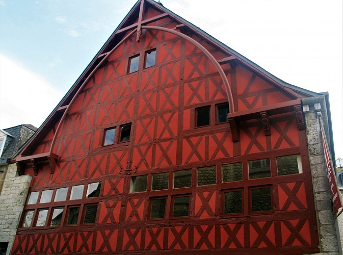
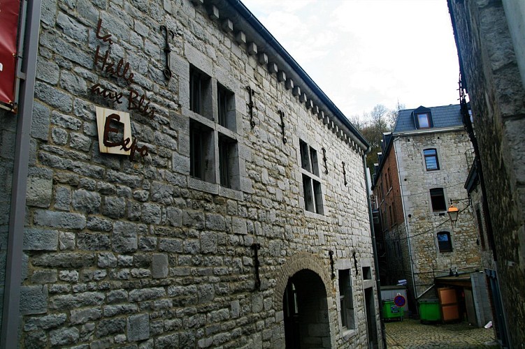
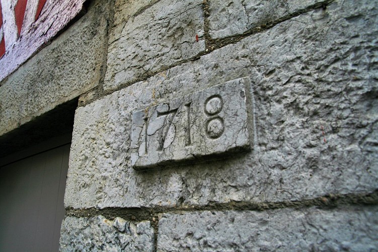
Let us linger for a moment outside one of the town’s iconic buildings, the Halle aux Blés or corn exchange, also known as the Spanish House. The earliest references to a building on this spot date from 1380, but the building we see today, with its extremely rare half-timbering, dates from the 16th century (around 1530- 1540) and bears witness to the economic importance of Durbuy at the time, whose lands covered what are now several different communes. Its designation as the Halle aux Blés is somewhat misleading, and dates from the 19th century. The building in fact served a number of different purposes, housing both a covered market and the magistracy (the administrative and judicial centre for the county). The town declined in importance in the 17th century, as a result of the Thirty Years War and the disappearance of the iron-founding industry. The building fell into disrepair and the rear half, which had housed the covered market, had to be demolished in 1639. In the 18th century, it underwent further transformations but retained its role as the town hall until the end of the century. The building is now listed as an outstanding example of Wallonian heritage (as of 23/11/1976) and is home to the Durbuy Museum of Modern and Contemporary Art.

281 Rue de la Vieille-Halle 6940 Durbuy
Lat : 50.3521628Lng : 5.4561871
150 m
Select background map

IGN MAP

IGN MAP

AERIAL PHOTOS / IGN

AERIAL PHOTOS / IGN

MULTI-SCALE MAPS / IGN

MULTI-SCALE MAPS / IGN

TOP 25 IGN

TOP 25 IGN

SLOPE MAP (IGN PLAN)

SLOPE MAP (IGN PLAN)

CADASTRAL PARCELS

CADASTRAL PARCELS

ICAO AERONAUTICAL CHARTS

ICAO AERONAUTICAL CHARTS

MAP 1950 / IGN

MAP 1950 / IGN

MAP OF THE GENERAL STAFF (1820-1866)

MAP OF THE GENERAL STAFF (1820-1866)

COASTAL MAPS / SHOM/IGN

COASTAL MAPS / SHOM/IGN

SCAN EXPRESS STANDARD / IGN

SCAN EXPRESS STANDARD / IGN

CLASSIC EXPRESS SCAN / IGN

CLASSIC EXPRESS SCAN / IGN

OPEN STREET MAP

OPEN STREET MAP

GOOGLE MAP - SATELLITE

GOOGLE MAP - SATELLITE

GOOGLE MAP - MAP

GOOGLE MAP - MAP

GOOGLE MAP - HYBRID

GOOGLE MAP - HYBRID

IGN BELGIUM

IGN BELGIUM
Nearby tours

Author Information

UNESCO Global Geopark Famenne-Ardenne Author