Geology & rocks

Signposted walk 1 (Fond des Vaulx)

Signposted walk 1 (Fond des Vaulx)

Marche-en-Famenne

On foot || Easy || 1:30 ||

6 km   1

Read more
8 LOD-A0-0030-2PMF 50.22951 5.34297
Felenne 7

Felenne 7

Felenne

On foot || Middle || Trail || Easy ||

10.0 km   7

Read more
8 ITB-01-000A4W 50.06775 4.84857
Signposted walk  2 (Paquerette/Daisy)

Signposted walk 2 (Paquerette/Daisy)

Marche-en-Famenne

On foot || Easy ||

9.8 km   2

Read more
8 LOD-A0-0030-2Q6U 50.22951 5.34297
Circuit Bomal-sur-Ourthe (Durbuy) -  The Saint Rahy walk

Circuit Bomal-sur-Ourthe (Durbuy) - The Saint Rahy walk

Bomal

On foot || Middle || 4:00 ||

9.86 km  

Read more
8 LOD-A0-008D-86UA 50.37907 5.52197
Felenne 3

Felenne 3

Felenne

On foot || Middle || 2:40 ||

10.0 km   3

Read more
8 ITB-01-000A4Y 50.06775 4.84857
Felenne 1

Felenne 1

Felenne

On foot || Middle || 2:45 ||

9.0 km  

Read more
8 ITB-01-000A4R 50.06775 4.84857
Promenade Hotton - 8- La Porte Aïve

Promenade Hotton - 8- La Porte Aïve

Hotton

On foot || Middle || 1:55 ||

7.15 km  

Read more
8 LOD-A0-008D-855J 50.2682 5.44797
Beauraing 1

Beauraing 1

Beauraing

On foot || Easy ||

7.5 km  

Read more
8 ITB-01-000A4H 50.10876 4.95972
Felenne 2

Felenne 2

Felenne

On foot || Middle || 3:15 ||

11 km   2

Read more
8 ITB-01-000A4S 50.06775 4.84857
Beauraing 2

Beauraing 2

Beauraing

On foot || Middle || 4:00 || Trail || Middle || 2:00 ||

15.0 km   croix jaune 2

Read more
8 ITB-01-000A4I 50.10876 4.95972
Walking trail  Hotton -17- Walk along the stones

Walking trail Hotton -17- Walk along the stones

Hotton

On foot || Middle || 1:50 ||

7.01 km  

Read more
8 LOD-A0-008D-84N1 50.26833 5.44806
Felenne 8

Felenne 8

Felenne

On foot || Middle || Trail || Easy ||

10.5 km   8

Read more
8 ITB-01-000A4U 50.06775 4.84857
Les pierres de légendes ( 1 ) (Commune DURBUY)

Les pierres de légendes ( 1 ) (Commune DURBUY)

Durbuy

On foot || Easy || 0:00 ||

6.36 km  

Read more
8 LOD-A0-008D-8J6A 50.32643 5.53234
Belvaux -  Les  Bouvreuils - The rapids of the Lesse

Belvaux - Les Bouvreuils - The rapids of the Lesse

Rochefort

On foot || Middle || 2:00 ||

5.63 km  

Read more
8 LOD-A0-008D-83PG 50.10607 5.19648
Felenne 4

Felenne 4

Felenne

On foot || Middle || 1:15 ||

3.5 km   4

Read more
8 ITB-01-000A4V 50.06775 4.84857
Les Rouges-Gorges

Les Rouges-Gorges

Belvaux

On foot || Middle || 3:45 || People with limited mobility || Pushchair ||

10.0 km  

Read more
8 ITB-01-000ATX 50.1658 5.18916
Les pierres de légendes ( 2 ) (Commune DURBUY)

Les pierres de légendes ( 2 ) (Commune DURBUY)

Durbuy

On foot || Easy || 1:15 ||

4.98 km  

Read more
8 LOD-A0-008D-8JMO 50.32641 5.53221
Les apéros feschautois

Les apéros feschautois

Feschaux

km  

Read more
9 EVT-A0-008J-1BKG 50.14726 4.9121
Felenne 6

Felenne 6

Felenne

On foot || Easy || 1:45 ||

7.5 km   6

Read more
8 ITB-01-000A4X 50.06775 4.84857

AND GEOTRAILS

Types of practices
Difficulty
Distance
Duration
Order
Reset filters

The mill at Lomprez

The mill at Lomprez
blur-effect
The mill at Lomprez
Credit : Geopark Famenne-Ardenne

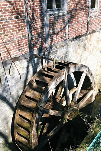
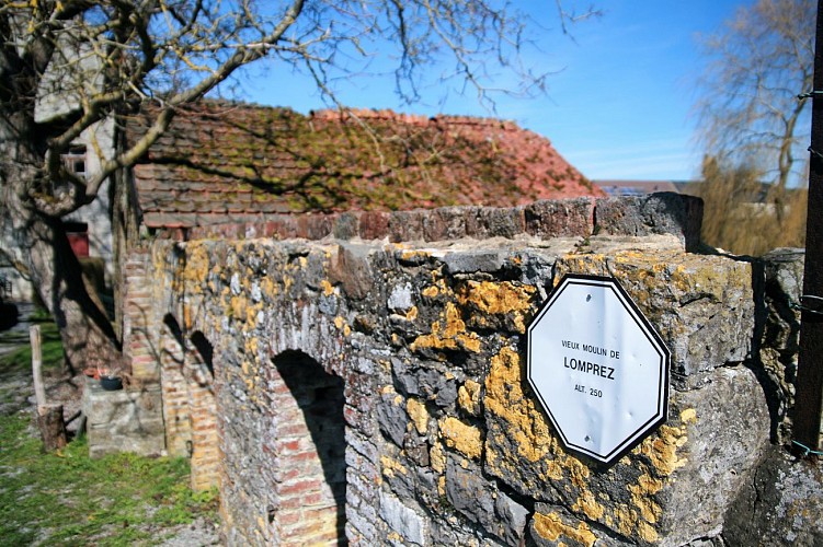
The mill at Lomprez is part of a group of buildings belonging historically to the fortified village of Lomprez. The mill stands alongside an imposing farmhouse said to date from the same period as a mediaeval castle built in the 12th century. The pond that once fed the millstream was dug out subsequently, on the orders of the Count La Roche. The mill is the last surviving building from this mediaeval period, and continued to operate as a working mill until 1920. The millwheel has now undergone renovation and the millpond has been replaced by a car park and a village hall (just behind you). Do pay a visit to the mill, if time permits: it is a unique opportunity for a close-up view of all the complicated machinery of millstones, sifters, hoppers, bucket conveyors and gear wheels, all still in place and all looking ready to resume their old tasks at a moment’s notice.

24 Vieille Route 6924 Wellin
Lat : 50.0760293Lng : 5.0944322
250 m
Select background map

IGN MAP

IGN MAP

AERIAL PHOTOS / IGN

AERIAL PHOTOS / IGN

MULTI-SCALE MAPS / IGN

MULTI-SCALE MAPS / IGN

TOP 25 IGN

TOP 25 IGN

SLOPE MAP (IGN PLAN)

SLOPE MAP (IGN PLAN)

CADASTRAL PARCELS

CADASTRAL PARCELS

ICAO AERONAUTICAL CHARTS

ICAO AERONAUTICAL CHARTS

MAP 1950 / IGN

MAP 1950 / IGN

MAP OF THE GENERAL STAFF (1820-1866)

MAP OF THE GENERAL STAFF (1820-1866)

COASTAL MAPS / SHOM/IGN

COASTAL MAPS / SHOM/IGN

SCAN EXPRESS STANDARD / IGN

SCAN EXPRESS STANDARD / IGN

CLASSIC EXPRESS SCAN / IGN

CLASSIC EXPRESS SCAN / IGN

OPEN STREET MAP

OPEN STREET MAP

GOOGLE MAP - SATELLITE

GOOGLE MAP - SATELLITE

GOOGLE MAP - MAP

GOOGLE MAP - MAP

GOOGLE MAP - HYBRID

GOOGLE MAP - HYBRID

IGN BELGIUM

IGN BELGIUM
Nearby tours

Author Information

UNESCO Global Geopark Famenne-Ardenne Author