Geology & rocks

Signposted walk 1 (Fond des Vaulx)

Signposted walk 1 (Fond des Vaulx)

Marche-en-Famenne

On foot || Easy || 1:30 ||

6 km   1

Read more
8 LOD-A0-0030-2PMF 50.22951 5.34297
Felenne 7

Felenne 7

Felenne

On foot || Middle || Trail || Easy ||

10.0 km   7

Read more
8 ITB-01-000A4W 50.06775 4.84857
Circuit Bomal-sur-Ourthe (Durbuy) -  The Saint Rahy walk

Circuit Bomal-sur-Ourthe (Durbuy) - The Saint Rahy walk

Bomal

On foot || Middle || 4:00 ||

9.86 km  

Read more
8 LOD-A0-008D-86UA 50.37907 5.52197
Signposted walk  2 (Paquerette/Daisy)

Signposted walk 2 (Paquerette/Daisy)

Marche-en-Famenne

On foot || Easy ||

9.8 km   2

Read more
8 LOD-A0-0030-2Q6U 50.22951 5.34297
Felenne 3

Felenne 3

Felenne

On foot || Middle || 2:40 ||

10.0 km   3

Read more
8 ITB-01-000A4Y 50.06775 4.84857
Promenade Hotton - 8- La Porte Aïve

Promenade Hotton - 8- La Porte Aïve

Hotton

On foot || Middle || 1:55 ||

7.15 km  

Read more
8 LOD-A0-008D-855J 50.2682 5.44797
Felenne 1

Felenne 1

Felenne

On foot || Middle || 2:45 ||

9.0 km  

Read more
8 ITB-01-000A4R 50.06775 4.84857
Beauraing 1

Beauraing 1

Beauraing

On foot || Easy ||

7.5 km  

Read more
8 ITB-01-000A4H 50.10876 4.95972
Felenne 2

Felenne 2

Felenne

On foot || Middle || 3:15 ||

11 km   2

Read more
8 ITB-01-000A4S 50.06775 4.84857
Beauraing 2

Beauraing 2

Beauraing

On foot || Middle || 4:00 || Trail || Middle || 2:00 ||

15.0 km   croix jaune 2

Read more
8 ITB-01-000A4I 50.10876 4.95972
Walking trail  Hotton -17- Walk along the stones

Walking trail Hotton -17- Walk along the stones

Hotton

On foot || Middle || 1:50 ||

7.01 km  

Read more
8 LOD-A0-008D-84N1 50.26833 5.44806
Felenne 8

Felenne 8

Felenne

On foot || Middle || Trail || Easy ||

10.5 km   8

Read more
8 ITB-01-000A4U 50.06775 4.84857
Les pierres de légendes ( 1 ) (Commune DURBUY)

Les pierres de légendes ( 1 ) (Commune DURBUY)

Durbuy

On foot || Easy || 0:00 ||

6.36 km  

Read more
8 LOD-A0-008D-8J6A 50.32643 5.53234
Felenne 4

Felenne 4

Felenne

On foot || Middle || 1:15 ||

3.5 km   4

Read more
8 ITB-01-000A4V 50.06775 4.84857
Belvaux -  Les  Bouvreuils - The rapids of the Lesse

Belvaux - Les Bouvreuils - The rapids of the Lesse

Rochefort

On foot || Middle || 2:00 ||

5.63 km  

Read more
8 LOD-A0-008D-83PG 50.10607 5.19648
Les Rouges-Gorges

Les Rouges-Gorges

Belvaux

On foot || Middle || 3:45 || People with limited mobility || Pushchair ||

10.0 km  

Read more
8 ITB-01-000ATX 50.1658 5.18916
Felenne 6

Felenne 6

Felenne

On foot || Easy || 1:45 ||

7.5 km   6

Read more
8 ITB-01-000A4X 50.06775 4.84857
Les pierres de légendes ( 2 ) (Commune DURBUY)

Les pierres de légendes ( 2 ) (Commune DURBUY)

Durbuy

On foot || Easy || 1:15 ||

4.98 km  

Read more
8 LOD-A0-008D-8JMO 50.32641 5.53221
Les apéros feschautois

Les apéros feschautois

Feschaux

km  

Read more
9 EVT-A0-008J-1BKG 50.14726 4.9121

AND GEOTRAILS

Types of practices
Difficulty
Distance
Duration
Order
Reset filters

The Drêve des Tilleuls and the Neo-Gothic Chapel

The Drêve des Tilleuls and the Neo-Gothic Chapel
blur-effect
The Drêve des Tilleuls and the Neo-Gothic Chapel
Credit : Geopark Famenne-Ardenne

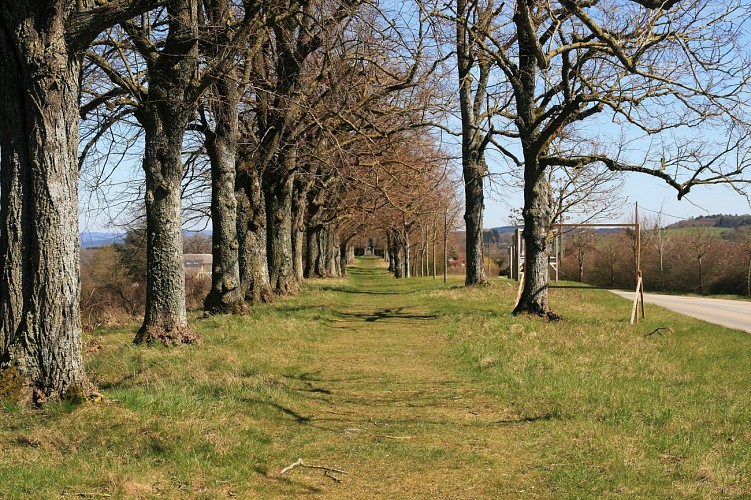
The Drève des Tilleuls and the Neo-Gothic Chapel This is the final stopping-place on your walk through the region of Wellin. The Drève, an avenue of linden trees, stands slightly outside the village on a hillside of clastic rock, and offers an impressive panorama. To the south, the land rises fairly smoothly, pastures fading in the distance into deep forests: this is the Ardennes. In the opposite direction, looking northward, the terrain is more varied. In the foreground, you can make out a depression, La Grande Fagne, carved out of soft rock easily eroded by a combination of frost and run-off, and by root action. This rock has the composition of clay but has been consolidated by a lengthy geological process into a hard rock known to geologists as schist. Beyond this depression, the land rises towards a wooded hill
running east to west, the Tienne de Reumont. Walking this hill, you will note a number of limestone outcrops indicating that we have now entered the Calestienne. After a stretch of schists, the limestone strip continues for over a kilometre (Bois de Haur). For an idea of the scale of the strip, we need to look west, towards the bell-tower of Lomprey church; just above the level of the motorway, you can make out the working face of the Limites quarry where the limestone is extracted. To the north of theCalestienne, the broad Famenne depression lies in the shales of the Upper Devonian, before the terrain rises sharply to the Condroz.
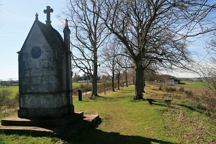
The Drève des Tilleuls leads to the Chapel of Our Lady of the Seven Sorrows, built in 1860 on the orders of
the Baroness Baré de Comogne. To reach the oratory, you must first negotiate the magnificent alley of trees
symbolising the seven sorrows of the Virgin. The chapel is neo-Gothic in style and built on asiltstone promontory. And since history is often interwoven with religion, in times of drought the faithful would come together in procession along the avenue to the chapel to pray for rain.

36 Rue de Lomprez 6920 Wellin
Lat : 50.070951Lng : 5.073747
299 m
Select background map

IGN MAP

IGN MAP

AERIAL PHOTOS / IGN

AERIAL PHOTOS / IGN

MULTI-SCALE MAPS / IGN

MULTI-SCALE MAPS / IGN

TOP 25 IGN

TOP 25 IGN

SLOPE MAP (IGN PLAN)

SLOPE MAP (IGN PLAN)

CADASTRAL PARCELS

CADASTRAL PARCELS

ICAO AERONAUTICAL CHARTS

ICAO AERONAUTICAL CHARTS

MAP 1950 / IGN

MAP 1950 / IGN

MAP OF THE GENERAL STAFF (1820-1866)

MAP OF THE GENERAL STAFF (1820-1866)

COASTAL MAPS / SHOM/IGN

COASTAL MAPS / SHOM/IGN

SCAN EXPRESS STANDARD / IGN

SCAN EXPRESS STANDARD / IGN

CLASSIC EXPRESS SCAN / IGN

CLASSIC EXPRESS SCAN / IGN

OPEN STREET MAP

OPEN STREET MAP

GOOGLE MAP - SATELLITE

GOOGLE MAP - SATELLITE

GOOGLE MAP - MAP

GOOGLE MAP - MAP

GOOGLE MAP - HYBRID

GOOGLE MAP - HYBRID

IGN BELGIUM

IGN BELGIUM
Nearby tours

Author Information

UNESCO Global Geopark Famenne-Ardenne Author