Geology & rocks

Felenne 7

Felenne 7

Felenne

On foot || Middle || Trail || Easy ||

10.0 km   7

Read more
8 ITB-01-000A4W 50.06775 4.84857
Signposted walk 1 (Fond des Vaulx)

Signposted walk 1 (Fond des Vaulx)

Marche-en-Famenne

On foot || Easy || 1:30 ||

6 km   1

Read more
8 LOD-A0-0030-2PMF 50.22951 5.34297
Circuit Bomal-sur-Ourthe (Durbuy) -  The Saint Rahy walk

Circuit Bomal-sur-Ourthe (Durbuy) - The Saint Rahy walk

Bomal

On foot || Middle || 4:00 ||

9.86 km  

Read more
8 LOD-A0-008D-86UA 50.37907 5.52197
Signposted walk  2 (Paquerette/Daisy)

Signposted walk 2 (Paquerette/Daisy)

Marche-en-Famenne

On foot || Easy ||

9.8 km   2

Read more
8 LOD-A0-0030-2Q6U 50.22951 5.34297
Felenne 3

Felenne 3

Felenne

On foot || Middle || 2:40 ||

10.0 km   3

Read more
8 ITB-01-000A4Y 50.06775 4.84857
Beauraing 1

Beauraing 1

Beauraing

On foot || Easy ||

7.5 km  

Read more
8 ITB-01-000A4H 50.10876 4.95972
Promenade Hotton - 8- La Porte Aïve

Promenade Hotton - 8- La Porte Aïve

Hotton

On foot || Middle || 1:55 ||

7.15 km  

Read more
8 LOD-A0-008D-855J 50.2682 5.44797
Felenne 1

Felenne 1

Felenne

On foot || Middle || 2:45 ||

9.0 km  

Read more
8 ITB-01-000A4R 50.06775 4.84857
Beauraing 2

Beauraing 2

Beauraing

On foot || Middle || 4:00 || Trail || Middle || 2:00 ||

15.0 km   croix jaune 2

Read more
8 ITB-01-000A4I 50.10876 4.95972
Felenne 2

Felenne 2

Felenne

On foot || Middle || 3:15 ||

11 km   2

Read more
8 ITB-01-000A4S 50.06775 4.84857
Walking trail  Hotton -17- Walk along the stones

Walking trail Hotton -17- Walk along the stones

Hotton

On foot || Middle || 1:50 ||

7.01 km  

Read more
8 LOD-A0-008D-84N1 50.26833 5.44806
Les pierres de légendes ( 1 ) (Commune DURBUY)

Les pierres de légendes ( 1 ) (Commune DURBUY)

Durbuy

On foot || Easy || 0:00 ||

6.36 km  

Read more
8 LOD-A0-008D-8J6A 50.32643 5.53234
Felenne 8

Felenne 8

Felenne

On foot || Middle || Trail || Easy ||

10.5 km   8

Read more
8 ITB-01-000A4U 50.06775 4.84857
Belvaux -  Les  Bouvreuils - The rapids of the Lesse

Belvaux - Les Bouvreuils - The rapids of the Lesse

Rochefort

On foot || Middle || 2:00 ||

5.63 km  

Read more
8 LOD-A0-008D-83PG 50.10607 5.19648
Les Rouges-Gorges

Les Rouges-Gorges

Belvaux

On foot || Middle || 3:45 || People with limited mobility || Pushchair ||

10.0 km  

Read more
8 ITB-01-000ATX 50.1658 5.18916
Les pierres de légendes ( 2 ) (Commune DURBUY)

Les pierres de légendes ( 2 ) (Commune DURBUY)

Durbuy

On foot || Easy || 1:15 ||

4.98 km  

Read more
8 LOD-A0-008D-8JMO 50.32641 5.53221
Felenne 4

Felenne 4

Felenne

On foot || Middle || 1:15 ||

3.5 km   4

Read more
8 ITB-01-000A4V 50.06775 4.84857
Les apéros feschautois

Les apéros feschautois

Feschaux

km  

Read more
9 EVT-A0-008J-1BKG 50.14726 4.9121
Felenne 6

Felenne 6

Felenne

On foot || Easy || 1:45 ||

7.5 km   6

Read more
8 ITB-01-000A4X 50.06775 4.84857

AND GEOTRAILS

Types of practices
Difficulty
Distance
Duration
Order
Reset filters

Trotti aux Fosses

Trotti aux Fosses
blur-effect
Trotti aux Fosses
Credit : Geopark Famenne-Ardenne

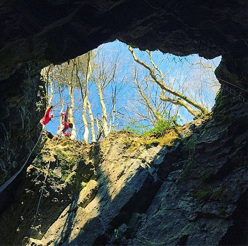
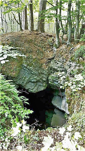
This is more or less the halfway point on the Fond des Vaulx route and here we find the most iconic karst phenomenon of all: the Trotti aux Fosses chasm, a vast collapse cavity (an underground space, the roof of which has gradually collapsed to the ground, Marche-en-Famenne Famenne-Ardenne unesco global Geopark 13 forming a huge well some 15 metres deep. The resulting limestone scree was gradually dissolved by the underground river beneath the Fond des Vaulx, accessible only to cavers.

Fond des Vaulx 6900 Marche-en-Famenne
Lat : 50.2290957Lng : 5.3681624
282 m
Select background map

IGN MAP

IGN MAP

AERIAL PHOTOS / IGN

AERIAL PHOTOS / IGN

MULTI-SCALE MAPS / IGN

MULTI-SCALE MAPS / IGN

TOP 25 IGN

TOP 25 IGN

SLOPE MAP (IGN PLAN)

SLOPE MAP (IGN PLAN)

CADASTRAL PARCELS

CADASTRAL PARCELS

ICAO AERONAUTICAL CHARTS

ICAO AERONAUTICAL CHARTS

MAP 1950 / IGN

MAP 1950 / IGN

MAP OF THE GENERAL STAFF (1820-1866)

MAP OF THE GENERAL STAFF (1820-1866)

COASTAL MAPS / SHOM/IGN

COASTAL MAPS / SHOM/IGN

SCAN EXPRESS STANDARD / IGN

SCAN EXPRESS STANDARD / IGN

CLASSIC EXPRESS SCAN / IGN

CLASSIC EXPRESS SCAN / IGN

OPEN STREET MAP

OPEN STREET MAP

GOOGLE MAP - SATELLITE

GOOGLE MAP - SATELLITE

GOOGLE MAP - MAP

GOOGLE MAP - MAP

GOOGLE MAP - HYBRID

GOOGLE MAP - HYBRID

IGN BELGIUM

IGN BELGIUM
Nearby tours

Author Information

UNESCO Global Geopark Famenne-Ardenne Author