Geology & rocks

Signposted walk 1 (Fond des Vaulx)

Signposted walk 1 (Fond des Vaulx)

Marche-en-Famenne

On foot || Easy || 1:30 ||

6 km   1

Read more
8 LOD-A0-0030-2PMF 50.22951 5.34297
Felenne 7

Felenne 7

Felenne

On foot || Middle || Trail || Easy ||

10.0 km   7

Read more
8 ITB-01-000A4W 50.06775 4.84857
Circuit Bomal-sur-Ourthe (Durbuy) -  The Saint Rahy walk

Circuit Bomal-sur-Ourthe (Durbuy) - The Saint Rahy walk

Bomal

On foot || Middle || 4:00 ||

9.86 km  

Read more
8 LOD-A0-008D-86UA 50.37907 5.52197
Signposted walk  2 (Paquerette/Daisy)

Signposted walk 2 (Paquerette/Daisy)

Marche-en-Famenne

On foot || Easy ||

9.8 km   2

Read more
8 LOD-A0-0030-2Q6U 50.22951 5.34297
Felenne 3

Felenne 3

Felenne

On foot || Middle || 2:40 ||

10.0 km   3

Read more
8 ITB-01-000A4Y 50.06775 4.84857
Felenne 1

Felenne 1

Felenne

On foot || Middle || 2:45 ||

9.0 km  

Read more
8 ITB-01-000A4R 50.06775 4.84857
Promenade Hotton - 8- La Porte Aïve

Promenade Hotton - 8- La Porte Aïve

Hotton

On foot || Middle || 1:55 ||

7.15 km  

Read more
8 LOD-A0-008D-855J 50.2682 5.44797
Beauraing 1

Beauraing 1

Beauraing

On foot || Easy ||

7.5 km  

Read more
8 ITB-01-000A4H 50.10876 4.95972
Felenne 2

Felenne 2

Felenne

On foot || Middle || 3:15 ||

11 km   2

Read more
8 ITB-01-000A4S 50.06775 4.84857
Walking trail  Hotton -17- Walk along the stones

Walking trail Hotton -17- Walk along the stones

Hotton

On foot || Middle || 1:50 ||

7.01 km  

Read more
8 LOD-A0-008D-84N1 50.26833 5.44806
Beauraing 2

Beauraing 2

Beauraing

On foot || Middle || 4:00 || Trail || Middle || 2:00 ||

15.0 km   croix jaune 2

Read more
8 ITB-01-000A4I 50.10876 4.95972
Felenne 8

Felenne 8

Felenne

On foot || Middle || Trail || Easy ||

10.5 km   8

Read more
8 ITB-01-000A4U 50.06775 4.84857
Les pierres de légendes ( 1 ) (Commune DURBUY)

Les pierres de légendes ( 1 ) (Commune DURBUY)

Durbuy

On foot || Easy || 0:00 ||

6.36 km  

Read more
8 LOD-A0-008D-8J6A 50.32643 5.53234
Felenne 4

Felenne 4

Felenne

On foot || Middle || 1:15 ||

3.5 km   4

Read more
8 ITB-01-000A4V 50.06775 4.84857
Belvaux -  Les  Bouvreuils - The rapids of the Lesse

Belvaux - Les Bouvreuils - The rapids of the Lesse

Rochefort

On foot || Middle || 2:00 ||

5.63 km  

Read more
8 LOD-A0-008D-83PG 50.10607 5.19648
Les pierres de légendes ( 2 ) (Commune DURBUY)

Les pierres de légendes ( 2 ) (Commune DURBUY)

Durbuy

On foot || Easy || 1:15 ||

4.98 km  

Read more
8 LOD-A0-008D-8JMO 50.32641 5.53221
Felenne 6

Felenne 6

Felenne

On foot || Easy || 1:45 ||

7.5 km   6

Read more
8 ITB-01-000A4X 50.06775 4.84857
Les Rouges-Gorges

Les Rouges-Gorges

Belvaux

On foot || Middle || 3:45 || People with limited mobility || Pushchair ||

10.0 km  

Read more
8 ITB-01-000ATX 50.1658 5.18916
Les apéros feschautois

Les apéros feschautois

Feschaux

km  

Read more
9 EVT-A0-008J-1BKG 50.14726 4.9121

AND GEOTRAILS

Types of practices
Difficulty
Distance
Duration
Order
Reset filters

Castel Saint-Pierre Communal Park

Castel Saint-Pierre Communal Park
blur-effect
Castel Saint-Pierre Communal Park
Credit : Geopark Famenne-Ardenne

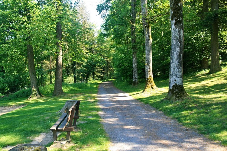
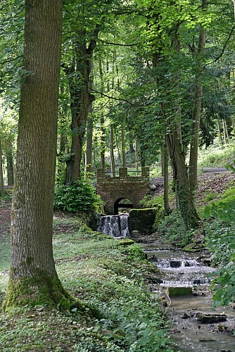
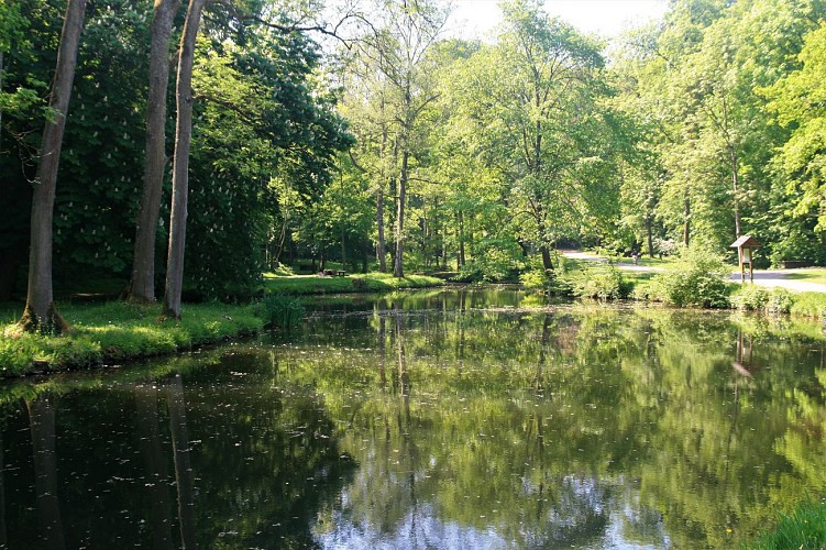
The trail starts from the Castel SaintPierre municipal park just a few minutes from Beauraing town centre. The park runs along the valley of a stream, the Dammaron, and features a series of ponds, low cliffs and woods occupying a total of 27 hectares. This is a wonderful spot for all kinds of leisure activities, from walking to fitness circuits and jogging or mountain-biking trails. There are a number of picnic areas with barbecues that are free for visitors to use. The park owes its name to the ancient Romanesque chapel, now a listed monument, dedicated to the first Bishop of Rome, Saint Peter. This park leads naturally into the Parc
du Castel Sainte-Marie, a 32-hectare estate that also offers endless opportunities for walks. There is no physical separation between the two parks, the first of which is municipal and the second of which is owned by the association ASBL Pro Maria but is open to the public. The two parks sere originally one, forming the 59-hectare “gardens” of Beauraing Castle. For those with an interest in botany, there is a small arboretum featuring over 50 forest species and a variety of different sorts of vegetation characteristic of the Calestienne. Approaching the exit, you will notice several sequoias, planted in the latter half of the 19th century. For the geology buffs, the upper car park stands on Eifelian sandstone but, as you head north, you
will gradually find yourself in an area of limestone rocks. It is mainly in the stream valley that you will find the
finest outcrops. This walk will take us to the secondary entrance to the Parc du Castel Sainte Marie some 1,500metresNNE on Rue du Luxembourg. Of all the possible options, we opted for a route using paths and tracks that can sometimes be a little steepbut offers a wilder, rockier setting.

86 N981 5570 Beauraing
Lat : 50.1018221Lng : 4.9486756
234 m
Select background map

IGN MAP

IGN MAP

AERIAL PHOTOS / IGN

AERIAL PHOTOS / IGN

MULTI-SCALE MAPS / IGN

MULTI-SCALE MAPS / IGN

TOP 25 IGN

TOP 25 IGN

SLOPE MAP (IGN PLAN)

SLOPE MAP (IGN PLAN)

CADASTRAL PARCELS

CADASTRAL PARCELS

ICAO AERONAUTICAL CHARTS

ICAO AERONAUTICAL CHARTS

MAP 1950 / IGN

MAP 1950 / IGN

MAP OF THE GENERAL STAFF (1820-1866)

MAP OF THE GENERAL STAFF (1820-1866)

COASTAL MAPS / SHOM/IGN

COASTAL MAPS / SHOM/IGN

SCAN EXPRESS STANDARD / IGN

SCAN EXPRESS STANDARD / IGN

CLASSIC EXPRESS SCAN / IGN

CLASSIC EXPRESS SCAN / IGN

OPEN STREET MAP

OPEN STREET MAP

GOOGLE MAP - SATELLITE

GOOGLE MAP - SATELLITE

GOOGLE MAP - MAP

GOOGLE MAP - MAP

GOOGLE MAP - HYBRID

GOOGLE MAP - HYBRID

IGN BELGIUM

IGN BELGIUM
Nearby tours

Author Information

UNESCO Global Geopark Famenne-Ardenne Author