
 7
7 
 1
1 
Circuit Bomal-sur-Ourthe (Durbuy) - The Saint Rahy walk
Bomal
On foot || Middle || 4:00 ||
 9.86 km


 2
2 


Beauraing 2
Beauraing
On foot || Middle || 4:00 || Trail || Middle || 2:00 ||
15.0 km
 croix jaune 2

Walking trail Hotton -17- Walk along the stones
Hotton
On foot || Middle || 1:50 ||
7.01 km


Belvaux - Les Bouvreuils - The rapids of the Lesse
Rochefort
On foot || Middle || 2:00 ||
5.63 km


Les Rouges-Gorges
Belvaux
On foot || Middle || 3:45 || People with limited mobility || Pushchair ||
10.0 km


The Pre-au-Tonneau Cave
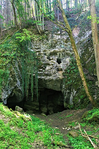

The entrance to the Pré-au-Tonneau Cave on the left bank of the Lomme is marked by an impressively large
entrance, leading to a perpendicular gallery running east to west. It was created by the collapse of the rock
wall separating the valley from the gallery that runs parallel to it. This was one of the main sink-holes on the Lomme, before the construction of a railway embankment in 1880 created a separation between the two. When the flow of water in the Lomme is powerful enough, the sinkholes upstream of the cave become active and feed into the gallery to the left of the entrance. The river continues its course to the right of the entrance before disappearing some 50 metres further on into a siphon.
IGN MAP

AERIAL PHOTOS / IGN


SLOPE MAP (IGN PLAN)


MAP 1950 / IGN

MAP OF THE GENERAL STAFF (1820-1866)


OPEN STREET MAP


Author Information

5580 Rochefort


