
 7
7 
 1
1 
Circuit Bomal-sur-Ourthe (Durbuy) - The Saint Rahy walk
Bomal
On foot || Middle || 4:00 ||
 9.86 km


 2
2 


Beauraing 2
Beauraing
On foot || Middle || 4:00 || Trail || Middle || 2:00 ||
15.0 km
 croix jaune 2

Walking trail Hotton -17- Walk along the stones
Hotton
On foot || Middle || 1:50 ||
7.01 km


Belvaux - Les Bouvreuils - The rapids of the Lesse
Rochefort
On foot || Middle || 2:00 ||
5.63 km

Les Rouges-Gorges
Belvaux
On foot || Middle || 3:45 || People with limited mobility || Pushchair ||
10.0 km


Former SNCB station
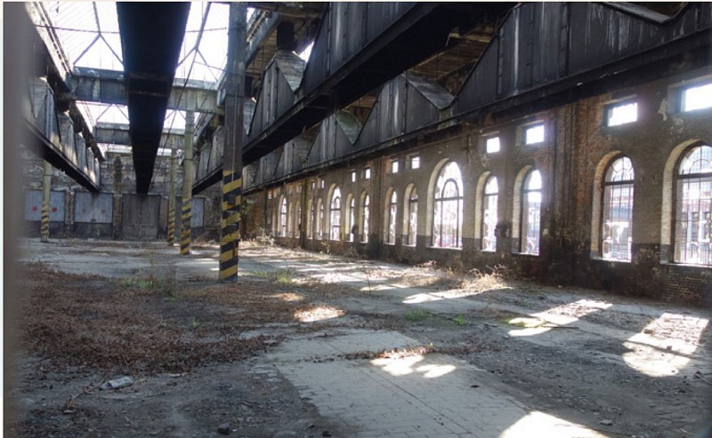

Arriving in Jemelle is something of a shock: in a few dozen metres, the terrain changes from nature and rocks to an entirely man-made setting: railway tracks, workshops (abandoned) and the SNCB station. The backdrop consists of (disused) quarry walls and the industrial plant of the quicklime works still operated by the Lhoist group. Keen photographers will find plenty of opportunities here, in the disused part of the station, for fascinating shots of old railway installations, unique in the Calestienne.
IGN MAP

AERIAL PHOTOS / IGN


SLOPE MAP (IGN PLAN)


MAP 1950 / IGN

MAP OF THE GENERAL STAFF (1820-1866)


OPEN STREET MAP


Author Information

5580 Rochefort


