

Nature - Promenade du Parc d'Ardenne à Houyet


Discover Houyet’ s rich Royal past and the beautiful Ardennes landscapes. The walk partially runs next to the rivers Lesse, and will take you along many natural treasures and a rather unique building, the "Halte d'Ardenne", once a royal train station. #WeLoveFamenneArdenne
Further information
Signalétique (EN)
Pedestrian - Diamond - Blue
IGN MAP

AERIAL PHOTOS / IGN


SLOPE MAP (IGN PLAN)


MAP 1950 / IGN

MAP OF THE GENERAL STAFF (1820-1866)


OPEN STREET MAP


Starting point
5560 Houyet
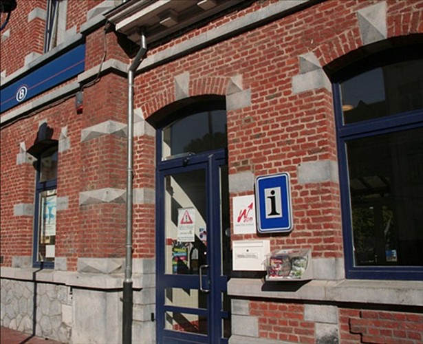
Houyet Tourist Information Centre
•Multilingual staff
•Information about the area : sightseeing, accommodation, sport, events...
•Charging station for e-bikes
•Large selection of walking maps for sale (including those form our walking maps section)
•WiFi
•Postcards for sale
+32(0)82 22 32 14
www.tourismehouyet.be
info@tourismehouyet.be
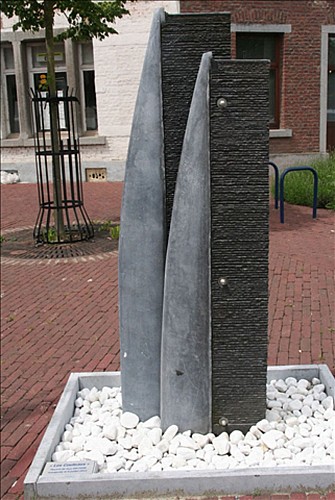
Sculpture
This sculpture called “Les Couteaux” (the knives) by Guy Deltour, a local artist, is here to remind us that Houyet used to be home to cutlery works of great renown. The factory produced hand–carved knives with a horn hilt for hunting, woodwork, etc. It is thought that the factory was started on request of King Leopold I circa 1850-1851.
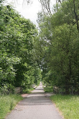
RAVeL foot and cycle path
A bit further on, you can spot one of the many access points to the Autonomous Network of Slow Ways (‘Réseau Autonome de Voies Lentes), known as the RAVel, and which links Jemelle to Houyet. This former railway line was dismantled after 1978 and rehabilitated as a lovely path for pedestrians, cyclists and other vulnerable road users.Several sections of the RAVeL run alongside the Lesse River, revealing some wonderful spots for an al fresco picnic.The distance between Houyet en Vignée is 6,2 km and Houyet and Rochefort are separated by 18,2 km
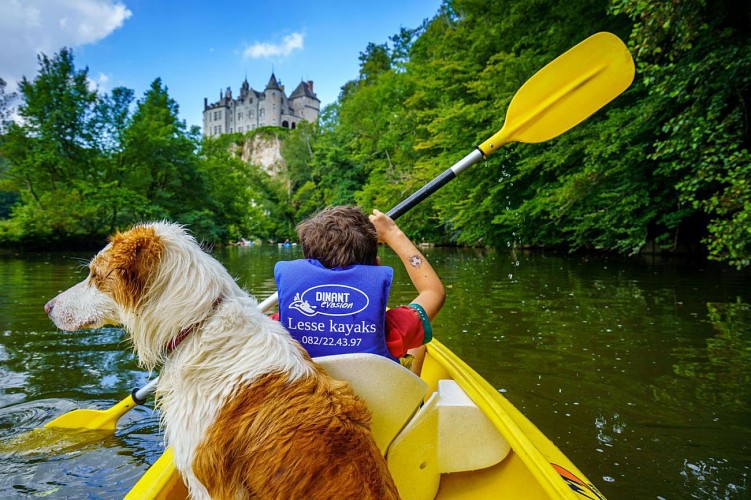
Canoeing on the Lesse
Houyet is also famous for canoeing down the Lesse!
Sensations guaranteed with the strong currents at the Castle of Walzin and Pont-à-Lesse. There are plenty of catering possibilities and pick nick areas dotted along the riverside. As you float by the renowned peaks of Chaleux, a listed heritage site towering over the Lesse River, you won’t fail to be impressed by the rock’s sheer majestic beauty. While canoeing along the twists and turns of this untamed river, you will be enraptured by the beauty of the scenery and the majesty of the rock formations that abound in the Ardennes.
Dinant Evasion
www.dinant-evasion.be
+32 (0) 82 22 43 97
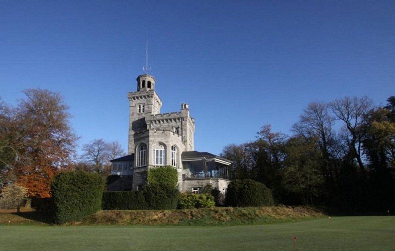
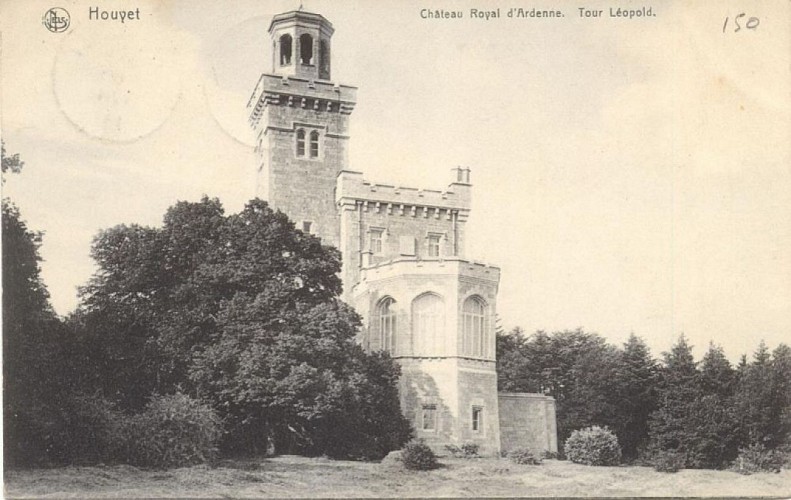
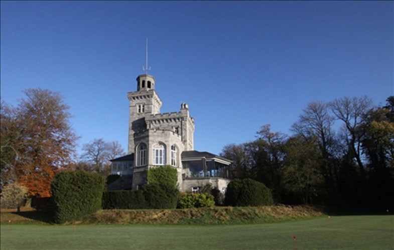
Léopold Tower
From here you can see the top of the Leopold Tower. The tower is located on the grounds of the Royal d’Ardenne golf club and is private property. In 1839, the domain started out as a humble hunting pavilion, but was later on extended and embellished under the architect Balat, eventually becoming a royal domain.The ‘tour du rocher( which literally means ‘tower on the rock’), known as the Leopold tower, was built in 1843 on the model of the tower in Windsor Park
Royal Domain
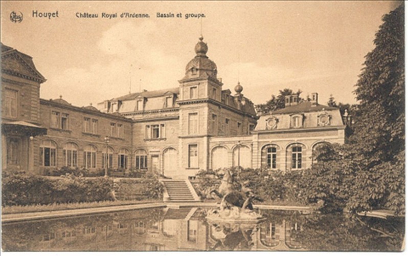
Houyet is often called the “the royal” municipality because of its rich royal history and because the village of Ciergnon is home to the royal castle which is assigned to the use of the current reigning family. King Leopold I had this castle built on request of his wife, Queen Louise-Mary (the construction started in 1842), but it was Leopold II who was wont to stay there on a regular basis. The brick façade was rebuilt with local limestone. Two square towers were added to the building as well as a number of water features that are scattered throughout the park. Before he died, Leopold II donated the domain to the State, so that it would be protected and preserved for posterity.The history of the national domain started in 1837, when Leopold I bought, only a couple of miles from here, the land called terre d’Hardenne et de Ferage. At the death of Leopold I, Leopold II continued the work of his predecessor. In 1874, he built the Royal Castle of Ardennes in Houyet in the magnificent park of the Domain of Ardennes. The castle became a hugely popular destination for the crowned heads of Europe and elsewhere. A park with water features was laid out and Leopold II managed to turn the domain into ‘the place to be’ for his rich Ostend clientele, who liked to organize their hunting parties there. The hotel was closed down at his death. The castle was pillaged during the First World War, and then turned into a hotel again from 1921 onwards. The hotel soon prospered and boasted 200 luxurious rooms, a golf course ‘golf du Château d’Ardenne’ (the Castle of Ardennes golf course). After being occupied by the Germans the second time round, the hotel, once again, closed its doors. On the afternoon of Friday 23 August 1968, a fire started in the castle, very nearly burning down everything in its path…..
Golf club
The path you are now following will take you through the golf club “Château Royal d’Ardenne”, please stay on the path and do not walk on the grass.
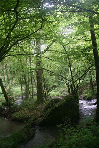
L'Ywoigne
Here we arrive at the confluence of the Lesse and the Iwoigne. This picturesque brook takes its source in Chevetogne, flows through Custinne and flows into the Lesse right here. You can follow this magnificent babbling brook’s course by taking the steep path on your left hand side.
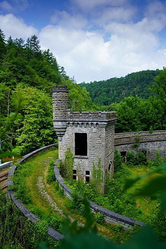
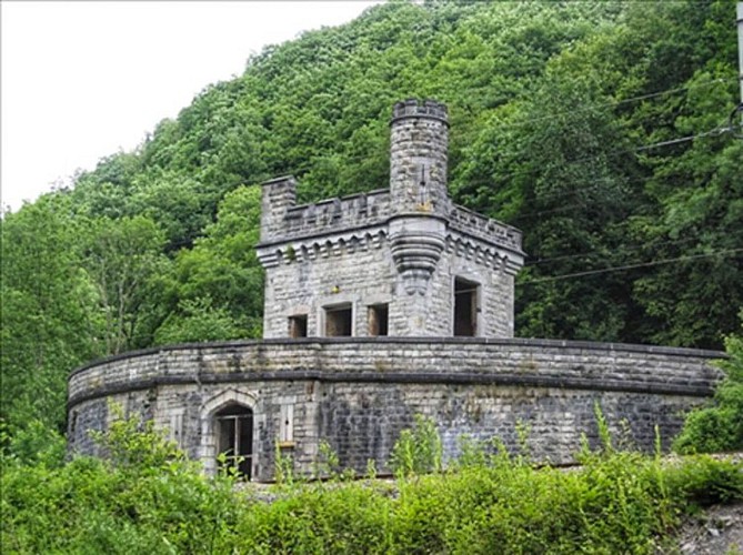
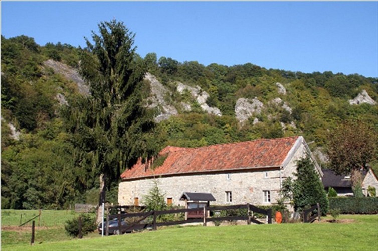
Halte Royal d'Ardenne - Train station
This station was once known as the "Royal Ardennes stop”, which referred to the Royal Ardennes Castle built in 1874 by King Leopold II. He wanted to turn Houyet into Belgium’s tourist hub and had the castle converted into a superb luxury hotel for the crowned heads and the privileged few of this world. From 1898 onwards the hotel was managed by the famous ‘Compagnie Internationale des Wagons-Lits’ (French for ‘International Sleeper Car Company’). After the construction of a railway line between Gendron-Celles and Houyet, railway line that was inaugurated on 01 April 1896, a station was built here in order to welcome the eminent guests staying the converted castle. Next to the rail, they built a thick round wall topped with a crenellated turret. The wall hides the road that leads to the castle, passing through the woods. In the seventies, several of the domain buildings were destroyed, but the ‘station’ remained untouched. As the hotel had been closed down after suffering heavy damages during the First World War, the station was also closed in 1919. A couple of years later, in 1921, the hotel was reopened but the station stayed closed for good.
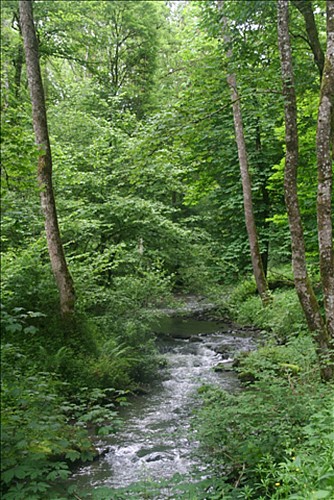
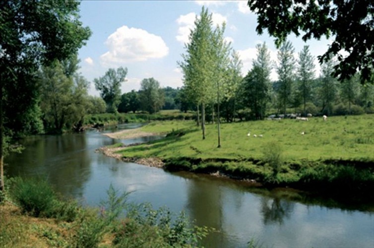
The river Lesse
This emblematic river has it source in the Province of Namur, more specifically in Ochamps, and winds its way northwards for about 84km (approx 52.2 miles). The Lesse crosses though the villages of Daverdisse, Halma, Chanly and Resteigne, and then plunges into the sinkhole of Belvaux on the heights of Han-sur-Lesse before reappearing at the cave exit and flowing towards Lessive, Villers-sur-Lesse and Houyet, terminating its journey in Anseremme, where the river flows into the Meuse. The Lesse is home to trout, grayling, pike, barbel, carp, chub, eels, minnows, gudgeon, grey slugs and lamprey...
Houyet Walking Map
We hope you enjoyed this walk. It is on the Houyet walking map which contains around 400km of signposted paths and more than 60 trails for hikers, cyclists, mountain bikers and horse riders.
You can buy this map for the modest sum of 7,50€.
+32(0)82 22 32 14
www.tourismehouyet.be
info@tourismehouyet.be


